
Curitiba topographic map
Interactive map
Click on the map to display elevation.
About this map
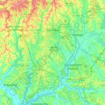
Name: Curitiba topographic map, elevation, terrain.
Average elevation: 2,989 ft
Minimum elevation: 2,818 ft
Maximum elevation: 3,468 ft
The city covers 432.17 km2 (166.86 sq mi) on the First Plateau of Paraná. Curitiba has a topography of smooth, rounded hills, giving it a relatively regular shape. The city has an average altitude of 934.6 m (3,066 ft) above sea level. The highest point is to the north at 1,021 m (3,350 ft), and with lower altitudes at 864 m (2,835 ft) to the south.
Other topographic maps
Click on a map to view its topography, its elevation and its terrain.
Adrianópolis
Brazil > Paraná > Região Metropolitana de Curitiba
Adrianópolis, Região Geográfica Imediata de Curitiba, Região Metropolitana de Curitiba, Região Geográfica Intermediária de Curitiba, Paraná, South Region, Brazil
Average elevation: 2,021 ft
Praça Brasil
Brazil > Paraná > Região Metropolitana de Curitiba > Fazenda Rio Grande
Praça Brasil, Fazenda Rio Grande, Região Geográfica Imediata de Curitiba, Região Metropolitana de Curitiba, Região Geográfica Intermediária de Curitiba, Paraná, South Region, Brazil
Average elevation: 2,936 ft
Rio Branco do Sul
Brazil > Paraná > Região Metropolitana de Curitiba > Rio Branco do Sul > Rio Branco do Sul
Rio Branco do Sul, Região Geográfica Imediata de Curitiba, Região Metropolitana de Curitiba, Região Geográfica Intermediária de Curitiba, Paraná, 83540-000, Brazil
Average elevation: 3,169 ft
Colombo
Brazil > Paraná > Região Metropolitana de Curitiba
Colombo, Região Geográfica Imediata de Curitiba, Região Metropolitana de Curitiba, Região Geográfica Intermediária de Curitiba, Paraná, South Region, Brazil
Average elevation: 3,189 ft
São José dos Pinhais
Brazil > Paraná > Região Metropolitana de Curitiba
São José dos Pinhais, Região Geográfica Imediata de Curitiba, Região Metropolitana de Curitiba, Região Geográfica Intermediária de Curitiba, Paraná, South Region, Brazil
Average elevation: 2,995 ft
Rio Branco do Sul
Brazil > Paraná > Região Metropolitana de Curitiba
Rio Branco do Sul, Região Geográfica Imediata de Curitiba, Região Metropolitana de Curitiba, Região Geográfica Intermediária de Curitiba, Paraná, South Region, Brazil
Average elevation: 2,526 ft