
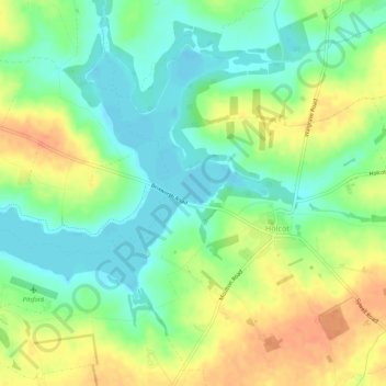
Pitsford Water topographic map
Interactive map
Click on the map to display elevation.
About this map
Name: Pitsford Water topographic map, elevation, terrain.
Average elevation: 351 ft
Minimum elevation: 289 ft
Maximum elevation: 430 ft
Other topographic maps
Click on a map to view its topography, its elevation and its terrain.
Crick
United Kingdom > England > Daventry > Crick
Crick, Daventry, Northamptonshire, East Midlands, England, NN6 7SP, United Kingdom
Average elevation: 446 ft
Naseby
United Kingdom > England > Daventry > Naseby
Naseby, Northamptonshire, East Midlands, England, NN6 6BZ, United Kingdom
Average elevation: 554 ft
Byfield
United Kingdom > England > Daventry > Byfield
Byfield, Daventry, Northamptonshire, East Midlands, England, NN11 6TZ, United Kingdom
Average elevation: 502 ft
Catesby
United Kingdom > England > Daventry > Hellidon
Catesby, Hellidon, West Northamptonshire, East Midlands, England, United Kingdom
Average elevation: 531 ft
Sulby
United Kingdom > England > Daventry
Sulby, Daventry, Northamptonshire, East Midlands, England, United Kingdom
Average elevation: 505 ft