
Dolores Hidalgo topographic map
Interactive map
Click on the map to display elevation.
About this map
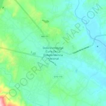
Name: Dolores Hidalgo topographic map, elevation, terrain.
Average elevation: 6,358 ft
Minimum elevation: 6,211 ft
Maximum elevation: 6,969 ft
It is located at 21°10′N 100°56′W / 21.17°N 100.93°W / 21.17; -100.93, at an elevation of about 1,980 meters (6,480 feet) above sea level. In the census of 2005 the city had a population of 54,843 people, while the municipality had 134,641 inhabitants. The city lies directly in the center of the municipality, which is 1,590 km² (613.9 sq mi) in area and includes numerous small outlying communities, the largest of which is Río Laja.