
River Corrib topographic map
Interactive map
Click on the map to display elevation.
About this map
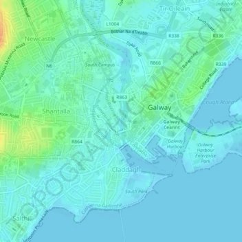
Name: River Corrib topographic map, elevation, terrain.
Average elevation: 23 ft
Minimum elevation: -3 ft
Maximum elevation: 121 ft
Other topographic maps
Click on a map to view its topography, its elevation and its terrain.
Parkmore
Ireland > Galway City > Galway City
Parkmore, Ballybrit, Galway City, County Galway, Connacht, Ireland
Average elevation: 121 ft
Renmore
Ireland > Galway City > Galway City
Renmore, Galway City, County Galway, Connacht, Ireland
Average elevation: 20 ft
Rahoon
Ireland > Galway City > Galway City
Rahoon, Galway City, County Galway, Connacht, Ireland
Average elevation: 138 ft
Wellpark
Ireland > Galway City > Galway City
Wellpark, Galway City, County Galway, Connacht, Ireland
Average elevation: 56 ft