
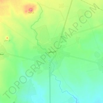
As Sanamayn topographic map
Interactive map
Click on the map to display elevation.
About this map
Name: As Sanamayn topographic map, elevation, terrain.
Average elevation: 2,103 ft
Minimum elevation: 1,985 ft
Maximum elevation: 2,346 ft
According to the Syria Central Bureau of Statistics (CBS), al-Sanamayn had a population of 26,268 in the 2004 census. In addition to being capital of the al-Sanamayn District, the city is also the administrative center and second largest locality of the al-Sanamayn nahiyah ("subdistrict") which consists of 16 localities with a collective population of 113,316 in 2004. The city's inhabitants are predominantly Sunni Muslims. Al-Sanamayn has an altitude of 640 metres (2,100 feet).
Other topographic maps
Click on a map to view its topography, its elevation and its terrain.
Bosra
Syria > Daraa Governorate > Bosra
Bosra, Busra Al-Sham Subdistrict, Daraa District, Daraa Governorate, Syria
Average elevation: 2,795 ft
Daraa District
Daraa District, Daraa Governorate, Syria
Average elevation: 2,185 ft
Daraa
Daraa, Daraa Subdistrict, Daraa District, Daraa Governorate, Syria
Average elevation: 1,791 ft
Kafr Shams
Kafr Shams, Al-Sanamayn Subdistrict, Al-Sanamayn District, Daraa Governorate, Syria
Average elevation: 2,362 ft