
Surtsey topographic map
Interactive map
Click on the map to display elevation.
About this map
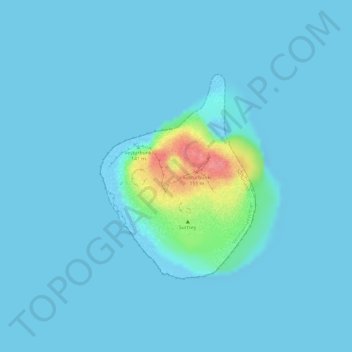
Name: Surtsey topographic map, elevation, terrain.
Location: Surtsey, Vestmannaeyjabær, Southern Region, Iceland (63.29609 -20.61748 63.31176 -20.59096)
Average elevation: 20 ft
Minimum elevation: 0 ft
Maximum elevation: 262 ft
Surtsey ("Surtr's island" in Icelandic, Icelandic pronunciation: [ˈsʏr̥(t)sˌeiː]) is a volcanic island located in the Vestmannaeyjar archipelago off the southern coast of Iceland. At 63°18′11″N 20°36′18″W / 63.303°N 20.605°W / 63.303; -20.605Coordinates: 63°18′11″N 20°36′18″W / 63.303°N 20.605°W / 63.303; -20.605 Surtsey is the southernmost point of Iceland. It was formed in a volcanic eruption which began 130 metres (430 feet) below sea level, and reached the surface on 14 November 1963. The eruption lasted until 5 June 1967, when the island reached its maximum size of 2.7 km2 (1.0 sq mi). Since then, wave erosion has caused the island to steadily diminish in size: as of 2012, its surface area was 1.3 km2 (0.50 sq mi). The most recent survey (2007) shows the island's maximum elevation at 155 m (509 ft) above sea level.