
Holywood topographic map
Interactive map
Click on the map to display elevation.
About this map
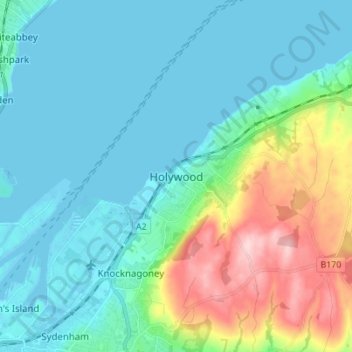
Name: Holywood topographic map, elevation, terrain.
Average elevation: 144 ft
Minimum elevation: -16 ft
Maximum elevation: 650 ft
Other topographic maps
Click on a map to view its topography, its elevation and its terrain.
Hilltown
United Kingdom > Northern Ireland > County Down
Hilltown, County Down, Northern Ireland, BT34 5UH, United Kingdom
Average elevation: 446 ft
Newtownards
United Kingdom > Northern Ireland > County Down
Newtownards, County Down, Northern Ireland, BT23 4FA, United Kingdom
Average elevation: 164 ft
Whiterock
United Kingdom > Northern Ireland > County Down
Whiterock, County Down, Northern Ireland, BT23 6QH, United Kingdom
Average elevation: 36 ft
Binian Lough
United Kingdom > Northern Ireland > County Down
Binian Lough, County Down, Northern Ireland, United Kingdom
Average elevation: 1,348 ft
Clough
United Kingdom > Northern Ireland > County Down
Clough, County Down, Ulster, Northern Ireland, BT30 8RB, United Kingdom
Average elevation: 105 ft
Carryduff
United Kingdom > Northern Ireland > County Down
Carryduff, County Down, Ulster, Northern Ireland, BT8 8DN, United Kingdom
Average elevation: 361 ft
Aughnahoory
United Kingdom > Northern Ireland > County Down > Kilkeel
Aughnahoory, Kilkeel, County Down, Ulster, Northern Ireland, United Kingdom
Average elevation: 197 ft
McLean's Hill
United Kingdom > Northern Ireland > County Down > Bryansford
McLean's Hill, Bryansford, County Down, Ulster, Northern Ireland, BT31 9HH, United Kingdom
Average elevation: 305 ft
Newry
United Kingdom > Northern Ireland > County Down > Newry
Newry, County Down, Northern Ireland, BT34 1DG, United Kingdom
Average elevation: 423 ft
Groomsport
United Kingdom > Northern Ireland > County Down > Groomsport
Groomsport, County Down, Northern Ireland, BT19 6JR, United Kingdom
Average elevation: 33 ft
Newry
United Kingdom > Northern Ireland > County Down > Newry
Newry, County Down, Northern Ireland, United Kingdom
Average elevation: 240 ft
Banbridge
United Kingdom > Northern Ireland > County Down
Banbridge, County Down, Ulster, Northern Ireland, BT32 3AD, United Kingdom
Average elevation: 295 ft
Dromore
United Kingdom > Northern Ireland > County Down
Dromore, County Down, Northern Ireland, BT25 1BL, United Kingdom
Average elevation: 348 ft