
Municipality of Peristeri topographic map
Interactive map
Click on the map to display elevation.
About this map
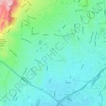
Name: Municipality of Peristeri topographic map, elevation, terrain.
Average elevation: 262 ft
Minimum elevation: 118 ft
Maximum elevation: 758 ft
Other topographic maps
Click on a map to view its topography, its elevation and its terrain.
Municipal Unit of Kamatero
Greece > Attica > Regional Unit of West Athens
Municipal Unit of Kamatero, Municipality of Agioi Anargyroi-Kamatero, Regional Unit of West Athens, Attica, 134 51, Greece
Average elevation: 502 ft
Peristeri
Greece > Attica > Regional Unit of West Athens
Peristeri, Municipality of Peristeri, Regional Unit of West Athens, Attica, 121 34, Greece
Average elevation: 732 ft
Municipality of Aigaleo
Greece > Attica > Regional Unit of West Athens
Municipality of Aigaleo, Regional Unit of West Athens, Attica, Greece
Average elevation: 151 ft
Municipality of Petroupoli
Greece > Attica > Regional Unit of West Athens
Municipality of Petroupoli, Regional Unit of West Athens, Attica, 132 31, Greece
Average elevation: 728 ft