
Newport County topographic map
Interactive map
Click on the map to display elevation.
About this map
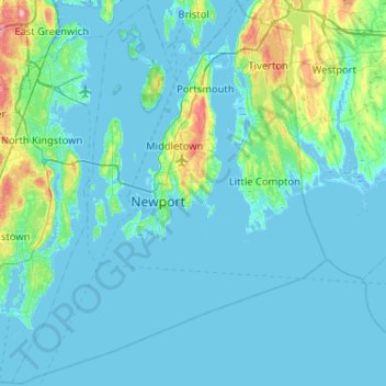
Name: Newport County topographic map, elevation, terrain.
Location: Newport County, Rhode Island, United States (41.30736 -71.50944 41.69050 -71.08857)
Average elevation: 46 ft
Minimum elevation: -23 ft
Maximum elevation: 427 ft
The county consists of Aquidneck Island, Conanicut Island, Prudence Island, and the easternmost portion of the state on the mainland. The highest point in the county is Pocasset Hill, 320 feet (98 m) above sea level, located in Tiverton. The lowest elevation is at sea level.
Other topographic maps
Click on a map to view its topography, its elevation and its terrain.
Barrington
United States > Rhode Island > Bristol County
Barrington, Bristol County, Rhode Island, 02806, United States
Average elevation: 13 ft
Cumberland
United States > Rhode Island > Providence County
Cumberland, Providence County, Rhode Island, 02864, United States
Average elevation: 249 ft
Aquidneck Island
United States > Rhode Island > Newport County > Portsmouth
Aquidneck Island, Portsmouth, Newport County, Rhode Island, United States
Average elevation: 43 ft
Warwick
United States > Rhode Island > Kent County
Warwick, Kent County, Rhode Island, United States
Average elevation: 52 ft
Goat Island
United States > Rhode Island > Newport County > Newport
Goat Island, Newport, Newport County, Rhode Island, United States
Average elevation: 7 ft
Westerly
United States > Rhode Island > South County
Westerly, South County, Rhode Island, 02808, United States
Average elevation: 62 ft
South Kingstown
United States > Rhode Island > South County
South Kingstown, South County, Rhode Island, United States
Average elevation: 98 ft
Tiverton
United States > Rhode Island > Newport County
Tiverton, Newport County, Rhode Island, 02878, United States
Average elevation: 102 ft
Chopmist
United States > Rhode Island > Providence County > Scituate
Chopmist, Scituate, Providence County, Rhode Island, 02857, United States
Average elevation: 574 ft
Diamond Hill
United States > Rhode Island > Providence County > Cumberland
Diamond Hill, Cumberland, Providence County, Rhode Island, 02864, United States
Average elevation: 262 ft
Providence
United States > Rhode Island > Providence County
Providence, Providence County, Rhode Island, United States
Average elevation: 62 ft
Charlestown
United States > Rhode Island > South County
Charlestown, South County, Rhode Island, 02813, United States
Average elevation: 72 ft
Cranston
United States > Rhode Island > Providence County
Cranston, Providence County, Rhode Island, United States
Average elevation: 89 ft
Jamestown
United States > Rhode Island > Newport County
Jamestown, Newport County, Rhode Island, 02835, United States
Average elevation: 26 ft
Wakefield
United States > Rhode Island > South County > South Kingstown
Wakefield, South Kingstown, South County, Rhode Island, 02879, United States
Average elevation: 75 ft
West Warwick
United States > Rhode Island > Kent County
West Warwick, Kent County, Rhode Island, United States
Average elevation: 194 ft
East Providence
United States > Rhode Island > Providence County
East Providence, Providence County, Rhode Island, United States
Average elevation: 39 ft
Middletown
United States > Rhode Island > Newport County
Middletown, Newport County, Rhode Island, 02842, United States
Average elevation: 62 ft
Masonic - Shriners Family Center
United States > Rhode Island > Kent County > Warwick
Masonic - Shriners Family Center, Warwick, Kent County, Rhode Island, United States
Average elevation: 23 ft
James V. Turner Reservoir
United States > Rhode Island > Providence County > East Providence > Rumford
James V. Turner Reservoir, Rumford, East Providence, Providence County, Rhode Island, United States
Average elevation: 46 ft
Page Island
United States > Rhode Island > Providence County > Pascoag
Page Island, Pascoag, Providence County, Rhode Island, 02859, United States
Average elevation: 407 ft
Portsmouth
United States > Rhode Island > Newport County
Portsmouth, Newport County, Rhode Island, United States
Average elevation: 62 ft
Narragansett Town Beach
United States > Rhode Island > South County > Narragansett > Narragansett Pier
Narragansett Town Beach, Narragansett Beach, Narragansett Pier, Narragansett, South County, Rhode Island, United States
Average elevation: 20 ft
West Warwick
United States > Rhode Island > Kent County
West Warwick, Kent County, Rhode Island, 02893, United States
Average elevation: 197 ft
Pawtucket
United States > Rhode Island > Providence County
Pawtucket, Providence County, Rhode Island, United States
Average elevation: 79 ft
Narragansett Bay
United States > Rhode Island > Newport County
Narragansett Bay, Newport County, Rhode Island, 02783, United States
Average elevation: 13 ft
Bristol
United States > Rhode Island > Bristol County
Bristol, Bristol County, Rhode Island, 02809, United States
Average elevation: 20 ft
Coventry
United States > Rhode Island > Kent County
Coventry, Kent County, Rhode Island, United States
Average elevation: 413 ft
Central Falls
United States > Rhode Island > Providence County
Central Falls, Providence County, Rhode Island, United States
Average elevation: 72 ft
Hell's Half Acre
United States > Rhode Island > Kent County > West Greenwich
Hell's Half Acre, West Greenwich, Kent County, Rhode Island, 02822, United States
Average elevation: 361 ft
Little Compton
United States > Rhode Island > Newport County
Little Compton, Newport County, Rhode Island, United States
Average elevation: 30 ft
Warren
United States > Rhode Island > Bristol County
Warren, Bristol County, Rhode Island, 02885, United States
Average elevation: 20 ft
Roosevelt Lake
United States > Rhode Island > Providence County > Providence
Roosevelt Lake, Providence, Providence County, Rhode Island, United States
Average elevation: 39 ft
North Providence
United States > Rhode Island > Providence County
North Providence, Providence County, Rhode Island, 02911, United States
Average elevation: 174 ft
Woonsocket
United States > Rhode Island > Providence County
Woonsocket, Providence County, Rhode Island, 02895, United States
Average elevation: 243 ft
Cunliff Pond Dam
United States > Rhode Island > Providence County > Providence
Cunliff Pond Dam, Providence, Providence County, Rhode Island, 02905, United States
Average elevation: 30 ft
Green Hill Point
United States > Rhode Island > South County > South Kingstown > Green Hill
Green Hill Point, Green Hill, South Kingstown, South County, Rhode Island, United States
Average elevation: 7 ft
Providence River
United States > Rhode Island > Providence County > Providence
Providence River, Providence, Providence County, Rhode Island, 02903, United States
Average elevation: 30 ft
Block Island
United States > Rhode Island > South County > New Shoreham
Block Island, New Shoreham, South County, Rhode Island, 02807, United States
Average elevation: 16 ft
Prudence Island
United States > Rhode Island > Newport County > Portsmouth
Prudence Island, Portsmouth, Newport County, Rhode Island, United States
Average elevation: 20 ft
Newport
United States > Rhode Island > Newport County
Newport, Newport County, Rhode Island, 02840, United States
Average elevation: 26 ft
Narragansett
United States > Rhode Island > South County
Narragansett, South County, Rhode Island, 02882, United States
Average elevation: 39 ft
Crompton
United States > Rhode Island > Kent County > West Warwick
Crompton, West Warwick, Kent County, Rhode Island, 02893, United States
Average elevation: 207 ft
Misquamicut
United States > Rhode Island > Washington County > Westerly
Misquamicut, Westerly, Washington County, Rhode Island, 02891, United States
Average elevation: 20 ft
North Smithfield
United States > Rhode Island > Providence County > North Smithfield
North Smithfield, Providence County, Rhode Island, United States
Average elevation: 315 ft
Providence County
Providence County, Rhode Island, United States
Average elevation: 354 ft
North Kingstown
United States > Rhode Island > South County
North Kingstown, South County, Rhode Island, United States
Average elevation: 115 ft
Burrillville
United States > Rhode Island > Providence County
Burrillville, Providence County, Rhode Island, United States
Average elevation: 509 ft
Newton Swamp Management Area
United States > Rhode Island > South County > Westerly
Newton Swamp Management Area, McGowan Corners, Westerly, South County, Rhode Island, 02808, United States
Average elevation: 72 ft
South County
South County, Rhode Island, United States
Average elevation: 98 ft