
Yuma topographic map
Interactive map
Click on the map to display elevation.
About this map
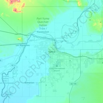
Name: Yuma topographic map, elevation, terrain.
Location: Yuma, Yuma County, Arizona, 85364, USA (32.53266 -114.78762 32.85266 -114.46762)
Average elevation: 226 ft
Minimum elevation: 85 ft
Maximum elevation: 1,667 ft
Other topographic maps
Click on a map to view its topography, its elevation and its terrain.
Yuma Territorial Prison State Historic Park
Yuma Territorial Prison State Historic Park, 220, Prison Hill Road, Yuma, Yuma County, Arizona, 85364, USA
Average elevation: 141 ft
Yuma Desert
Yuma Desert, Avenue 3E, Yuma, Yuma County, Arizona, USA
Average elevation: 282 ft
Yuma Quartermaster Depot State Historic Park
Yuma Quartermaster Depot State Historic Park, Yuma, Yuma County, Arizona, USA
Average elevation: 144 ft