
Préfecture d'Osaka topographic map
Interactive map
Click on the map to display elevation.
About this map
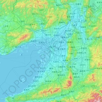
Name: Préfecture d'Osaka topographic map, elevation, terrain.
Location: Préfecture d'Osaka, Japon (34.27182 135.02589 35.05129 135.74660)
Average elevation: 574 ft
Minimum elevation: -26 ft
Maximum elevation: 4,659 ft
Other topographic maps
Click on a map to view its topography, its elevation and its terrain.