
Kavala topographic map
Interactive map
Click on the map to display elevation.
About this map
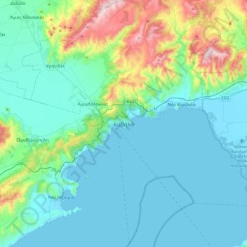
Name: Kavala topographic map, elevation, terrain.
Average elevation: 568 ft
Minimum elevation: -10 ft
Maximum elevation: 3,228 ft
On July 16, 2022, Meridian Flight 3032 crashed near the village. The Ukrainian-registered Antonov An-12BK was carrying 11.5 tons of ammunition from Niš to Dhaka when the plane began to lose altitude over the Aegean and turned around, but went down 35 kilometers west of Kavala Airport. All 8 crew members were killed.
Other topographic maps
Click on a map to view its topography, its elevation and its terrain.
Nea Peramos
Greece > Macedonia and Thrace > Kavala Regional Unit
Nea Peramos, Paggaio Municipality, Kavala Regional Unit, Eastern Macedonia and Thrace, Macedonia and Thrace, 640 07, Greece
Average elevation: 135 ft