
Taunton topographic map
Interactive map
Click on the map to display elevation.
About this map
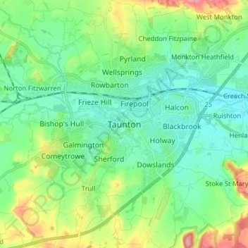
Name: Taunton topographic map, elevation, terrain.
Average elevation: 128 ft
Minimum elevation: 23 ft
Maximum elevation: 400 ft
Other topographic maps
Click on a map to view its topography, its elevation and its terrain.
Luxborough
United Kingdom > England > Somerset > Somerset West and Taunton
Luxborough, Somerset West and Taunton, Somerset, England, United Kingdom
Average elevation: 958 ft
Minehead
United Kingdom > England > Somerset > Somerset West and Taunton
Minehead, Somerset West and Taunton, Somerset, England, United Kingdom
Average elevation: 282 ft
Allerford
United Kingdom > England > Somerset > Somerset West and Taunton > Allerford
Allerford, Somerset West and Taunton, Somerset, England, TA24 8HN, United Kingdom
Average elevation: 367 ft
Porlock
United Kingdom > England > Somerset > Somerset West and Taunton > Porlock
Porlock, Somerset West and Taunton, Somerset, England, United Kingdom
Average elevation: 679 ft
Bossington
United Kingdom > England > Somerset > Somerset West and Taunton > Bossington
Bossington, Somerset West and Taunton, Somerset, England, TA24 8HQ, United Kingdom
Average elevation: 226 ft
Horner Water
United Kingdom > England > Somerset > Somerset West and Taunton > Luccombe
Horner Water, Luccombe, Somerset West and Taunton, Somerset, England, TA24 8HY, United Kingdom
Average elevation: 814 ft
Halse Combe
United Kingdom > England > Somerset > Somerset West and Taunton > Allerford > Horner
Halse Combe, Horner, Luccombe, Allerford, Somerset West and Taunton, Somerset, England, TA24 8HX, United Kingdom
Average elevation: 440 ft
Watchet
United Kingdom > England > Somerset > Somerset West and Taunton
Watchet, Somerset West and Taunton, Somerset, England, United Kingdom
Average elevation: 66 ft