
Praga-Południe topographic map
Interactive map
Click on the map to display elevation.
About this map
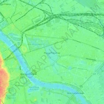
Name: Praga-Południe topographic map, elevation, terrain.
Location: Praga-Południe, Warsaw, Warszawa, Masovian Voivodeship, Poland (52.21528 21.03685 52.26047 21.13254)
Average elevation: 282 ft
Minimum elevation: 236 ft
Maximum elevation: 394 ft
Other topographic maps
Click on a map to view its topography, its elevation and its terrain.
Warsaw
Poland > Masovian Voivodeship > Warsaw
Warsaw, Masovian Voivodeship, Poland
Average elevation: 312 ft
Czerniaków
Poland > Masovian Voivodeship > Warsaw
Czerniaków, Mokotów, Warsaw, Masovian Voivodeship, Poland
Average elevation: 282 ft