
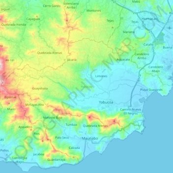
Yabucoa topographic map
Interactive map
Click on the map to display elevation.
About this map
Name: Yabucoa topographic map, elevation, terrain.
Location: Yabucoa, Puerto Rico, 00767, United States (18.01135 -66.01078 18.12612 -65.79516)
Average elevation: 387 ft
Minimum elevation: -7 ft
Maximum elevation: 1,857 ft
The municipality of Yabucoa is located in the south-eastern coast of Puerto Rico. The Valley of Yabucoa is surrounded by the hills of the San Lorenzo Batholith on three sides and by the Caribbean Sea on the fourth. The hills surrounding the Yabucoa Valley as well as the bedrock underlying the alluvium in the valley are composed of the San Lorenzo Batholith, a large, igneous intrusive body emplaced during the Late Cretaceous (Rogers, 1977; Rogers and others, 1979). The San Lorenzo Batholith is a composite body that is composed of gabbro (Kd), diorite, tonalite, granodiorite, and quartz monzonite. The Cuchillas de Panduras, a fork of the Sierra de Cayey in the Cordillera Central runs through its south. Santa Elena is one of its most prominent peaks with an altitude of 1,870 feet (570 meters). Santa Elena is located in Juan Martin ward. Pandura Peak rises 1,693 feet (516 meters) above sea level. Pandura is located in the Calabazas ward. The altitude of the hills surrounding the Valley of Yabucoa reaches a maximum of about 2,130 feet (650 meters) at the head of the Río Guayanés basin. The land surface in the Yabucoa Valley slopes gently from an altitude of about 98 feet (30 meters) above mean sea level, at the western edge of the valley, to sea level where the valley meets the Caribbean Sea.
Other topographic maps
Click on a map to view its topography, its elevation and its terrain.
Rincón
United States > Puerto Rico > Cidra
Rincón, Cidra, Puerto Rico, United States
Average elevation: 1,375 ft
Sector Pepe Morales
United States > Puerto Rico > Naranjito > Naranjito
Sector Pepe Morales, Cedro Abajo, Naranjito, Puerto Rico, 00719, United States
Average elevation: 1,385 ft
San Isidro
United States > Puerto Rico > Canóvanas
San Isidro, Canóvanas, Puerto Rico, United States
Average elevation: 95 ft
Florida
Florida, Puerto Rico, 00650, United States
Average elevation: 656 ft
Cerro Gonzalo
United States > Puerto Rico > Aguadilla
Cerro Gonzalo, Barrio Pueblo, Aguadilla, Puerto Rico, 00605, United States
Average elevation: 190 ft
Rincón
United States > Puerto Rico > Cayey
Rincón, Cayey, Puerto Rico, 00737, United States
Average elevation: 1,289 ft
Hatillo
Hatillo, Puerto Rico, 00659, United States
Average elevation: 627 ft
San Lorenzo
San Lorenzo, Puerto Rico, 00754, United States
Average elevation: 784 ft
Vieques
Vieques, Puerto Rico, 00765, United States
Average elevation: 16 ft
Yauco
United States > Puerto Rico > Yauco
Yauco, Puerto Rico, 00768, United States
Average elevation: 338 ft
Bosque Estatal Los Tres Picachos
United States > Puerto Rico > Ciales > Jayuya
Bosque Estatal Los Tres Picachos, Toro Negro, Jayuya, Ciales, Puerto Rico, United States
Average elevation: 2,352 ft
Sector María López
United States > Puerto Rico > Bayamón
Sector María López, Cerro Gordo, Bayamón, Puerto Rico, 00957, United States
Average elevation: 335 ft
Wilderness Beach, Base Ramey
United States > Puerto Rico > Aguadilla
Wilderness Beach, Base Ramey, Borinquen, Aguadilla, Puerto Rico, 00604, United States
Average elevation: 36 ft
Mansiones de Culebrina
United States > Puerto Rico > San Sebastián
Mansiones de Culebrina, Culebrinas, San Sebastián, Puerto Rico, 00685, United States
Average elevation: 374 ft
Cabo Rojo
United States > Puerto Rico > Cabo Rojo
Cabo Rojo, Puerto Rico, 00623-0910, United States
Average elevation: 148 ft
Sector Los Bruseles
United States > Puerto Rico > San Lorenzo
Sector Los Bruseles, Quebrada, San Lorenzo, Puerto Rico, 00778, United States
Average elevation: 436 ft
Cerro de Punta
United States > Puerto Rico > Ponce
Cerro de Punta, Ponce, Puerto Rico, 00654, United States
Average elevation: 3,350 ft
Isla de Mona
United States > Puerto Rico > Mayagüez
Isla de Mona, Mayagüez, Puerto Rico, United States
Average elevation: 85 ft
Adjuntas
United States > Puerto Rico > Adjuntas
Adjuntas, Puerto Rico, 00601, United States
Average elevation: 2,257 ft
Vega Alta
Vega Alta, Puerto Rico, 00692, United States
Average elevation: 246 ft
Naguabo
United States > Puerto Rico > Naguabo > Naguabo
Naguabo, Puerto Rico, 00718, United States
Average elevation: 177 ft
Trujillo Alto
Trujillo Alto, Puerto Rico, United States
Average elevation: 335 ft
Juana Díaz
Juana Díaz, Puerto Rico, United States
Average elevation: 518 ft
Mosquito
United States > Puerto Rico > Vieques
Mosquito, Vieques, Puerto Rico, United States
Average elevation: 128 ft
Aguadilla
United States > Puerto Rico > Aguadilla > Aguadilla
Aguadilla, Puerto Rico, 00605, United States
Average elevation: 200 ft
Lares
United States > Puerto Rico > Lares
Lares, Puerto Rico, United States
Average elevation: 1,270 ft
Aguas Buenas
Aguas Buenas, Puerto Rico, 00703, United States
Average elevation: 1,106 ft
Río Grande
United States > Puerto Rico > Rincón
Río Grande, Rincón, Puerto Rico, United States
Average elevation: 131 ft
East Ridge
United States > Puerto Rico > Mayagüez
East Ridge, Sabanetas, Mayagüez, Puerto Rico, United States
Average elevation: 30 ft
Cerro Prieto
United States > Puerto Rico > Utuado
Cerro Prieto, Utuado, Puerto Rico, United States
Average elevation: 2,133 ft