
Cantabrian Mountains topographic map
Interactive map
Click on the map to display elevation.
About this map
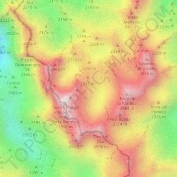
Name: Cantabrian Mountains topographic map, elevation, terrain.
Location: Cantabrian Mountains, Cabrales, Asturias, Spain (43.20006 -4.84787 43.20016 -4.84777)
Average elevation: 7,254 ft
Minimum elevation: 5,686 ft
Maximum elevation: 8,612 ft
Other topographic maps
Click on a map to view its topography, its elevation and its terrain.
Bulnes de Arriba (El Castillo)
Spain > Asturias > Cabrales > Bulnes de Arriba (El Castillo)
Bulnes de Arriba (El Castillo), Cabrales, Asturias, 33554, Spain
Average elevation: 3,734 ft