
Puigcerdà topographic map
Interactive map
Click on the map to display elevation.
About this map
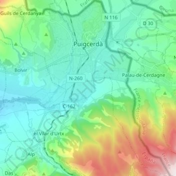
Name: Puigcerdà topographic map, elevation, terrain.
Location: Puigcerdà, Cerdanya, Girona, Catalonia, 17520, Spain (42.36193 1.89820 42.45464 1.98641)
Average elevation: 4,213 ft
Minimum elevation: 3,481 ft
Maximum elevation: 6,598 ft
Other topographic maps
Click on a map to view its topography, its elevation and its terrain.
Lles de Cerdanya
Lles de Cerdanya, Cerdanya, Lleida, Catalonia, 25726, Spain
Average elevation: 6,243 ft