
Roštín topographic map
Interactive map
Click on the map to display elevation.
About this map
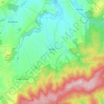
Name: Roštín topographic map, elevation, terrain.
Average elevation: 1,158 ft
Minimum elevation: 758 ft
Maximum elevation: 1,896 ft
Roštín is located about 14 kilometres (9 mi) southwest of Kroměříž and 27 km (17 mi) west of Zlín. The northwestern half of the municipality lies in the Litenčice Hills. The southeastern half lies in a forested landscape of the Chřiby range. Brdo, the highest mountain of the whole Central Moravian Carpathians region with an elevation of 587 m (1,926 ft), is located in the municipality.
Other topographic maps
Click on a map to view its topography, its elevation and its terrain.
Sazovice
Czechia > Central Moravia > Zlínský kraj
Sazovice, okres Zlín, Zlínský kraj, Central Moravia, Czechia
Average elevation: 771 ft
Stupava
Czechia > Central Moravia > Zlínský kraj
Stupava, okres Uherské Hradiště, Zlínský kraj, Central Moravia, Czechia
Average elevation: 1,404 ft
Kroměříž
Czechia > Central Moravia > Zlínský kraj
Kroměříž, okres Kroměříž, Zlínský kraj, Central Moravia, 767 01, Czechia
Average elevation: 722 ft
Rožnov pod Radhoštěm
Czechia > Central Moravia > Zlínský kraj
Rožnov pod Radhoštěm, okres Vsetín, Zlínský kraj, Central Moravia, 756 61, Czechia
Average elevation: 1,709 ft