
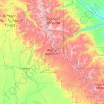
Bridger Wilderness topographic map
Interactive map
Click on the map to display elevation.
About this map
Name: Bridger Wilderness topographic map, elevation, terrain.
Average elevation: 8,783 ft
Minimum elevation: 5,676 ft
Maximum elevation: 13,635 ft
There are 600 miles (970 km) of hiking trails maintained in the wilderness, but with much of the terrain being steep and with many large mountain peaks to climb, many trails provide access climbing routes. Camping is permitted as long as a distance of at least 200 feet (61 m) minimum is maintained away from lakes and streams. Due to the high altitude associated with this wilderness, it is not uncommon to have freezing weather, especially at night anytime of the year. In the summer months mosquitos can also be a problem.
Other topographic maps
Click on a map to view its topography, its elevation and its terrain.
Downs Mountain
United States > Wyoming > Sublette County
Downs Mountain, Sublette County, Wyoming, United States
Average elevation: 12,392 ft
Big Sandy Lake
United States > Wyoming > Sublette County
Big Sandy Lake, Sublette County, Wyoming, United States
Average elevation: 10,180 ft
Pine Creek
United States > Wyoming > Sublette County > Pinedale
Pine Creek, Pinedale, Sublette County, Wyoming, 82941, United States
Average elevation: 7,178 ft
Pinedale
United States > Wyoming > Sublette County
Pinedale, Sublette County, Wyoming, 82941, United States
Average elevation: 7,205 ft