
Arches National Park topographic map
Interactive map
Click on the map to display elevation.
About this map
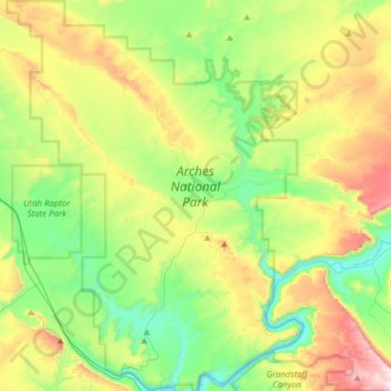
Name: Arches National Park topographic map, elevation, terrain.
Location: Arches National Park, Grand County, Utah, United States (38.60474 -109.71320 38.84693 -109.47771)
Average elevation: 4,843 ft
Minimum elevation: 3,957 ft
Maximum elevation: 6,545 ft
The park consists of 310.31 square kilometres (76,680 acres; 119.81 sq mi; 31,031 ha) of high desert located on the Colorado Plateau. The highest elevation in the park is 5,653 feet (1,723 m) at Elephant Butte, and the lowest elevation is 4,085 feet (1,245 m) at the visitor center. The park receives an average of less than 10 inches (250 mm) of rain annually.
Other topographic maps
Click on a map to view its topography, its elevation and its terrain.
Moab
United States > Utah > Grand County
Moab, Grand County, Utah, 84532, United States
Average elevation: 4,452 ft
Westwater
United States > Utah > Grand County
Westwater, Grand County, Utah, United States
Average elevation: 4,426 ft
Cisco
United States > Utah > Grand County
Cisco, Grand County, Utah, 84515, United States
Average elevation: 4,377 ft
Rectory
United States > Utah > Grand County
Rectory, Grand County, Utah, United States
Average elevation: 5,010 ft
Delicate Arch
United States > Utah > Grand County
Delicate Arch, Delicate Arch Trail, Grand County, Utah, United States
Average elevation: 4,623 ft
Thompson Springs
United States > Utah > Grand County
Thompson Springs, Grand County, Utah, 84540, United States
Average elevation: 5,194 ft
Colorado River
United States > Utah > Grand County > Moab
Colorado River, Moab, Grand County, Utah, United States
Average elevation: 5,472 ft
Castle Valley
United States > Utah > Grand County
Castle Valley, Grand County, Utah, United States
Average elevation: 5,282 ft
Cottonwood Point
United States > Utah > Grand County
Cottonwood Point, Grand County, Utah, United States
Average elevation: 7,697 ft
La Sal Mountains Viewpoint
United States > Utah > Grand County
La Sal Mountains Viewpoint, Main Park Road, Grand County, Utah, 84532-2134, United States
Average elevation: 4,419 ft