
Yegen topographic map
Interactive map
Click on the map to display elevation.
About this map
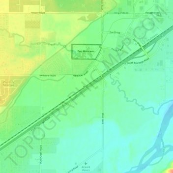
Name: Yegen topographic map, elevation, terrain.
Location: Yegen, Yellowstone County, Montana, United States (45.70356 -108.64264 45.74356 -108.60264)
Average elevation: 3,219 ft
Minimum elevation: 3,166 ft
Maximum elevation: 3,304 ft
Other topographic maps
Click on a map to view its topography, its elevation and its terrain.
Billings
United States > Montana > Yellowstone County
Billings, Yellowstone County, Montana, United States
Average elevation: 3,356 ft
Huntley
United States > Montana > Yellowstone County
Huntley, Yellowstone County, Montana, United States
Average elevation: 3,031 ft
Laurel
United States > Montana > Yellowstone County
Laurel, Yellowstone County, Montana, United States
Average elevation: 3,343 ft