
Anamudi topographic map
Interactive map
Click on the map to display elevation.
About this map
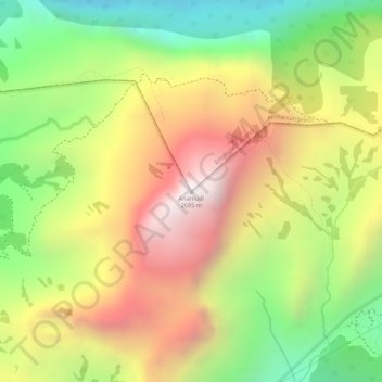
Name: Anamudi topographic map, elevation, terrain.
Average elevation: 7,247 ft
Minimum elevation: 5,587 ft
Maximum elevation: 8,809 ft
Anamudi is a mountain located in Ernakulam district and Idukki district of the Indian state of Kerala. It is the highest peak in the Western Ghats and in South India, at an elevation of 2,695 metres (8,842 ft) and a topographic prominence of 2,479 metres (8,133 ft). The name Anamudi literally translates to "elephant's head" a reference to the resemblance of the mountain to an elephant's head. Anamudi is the highest mountain in peninsular India as well as the largest mountain in Kerala. Meanwhile, the highest independent mountain (free-standing mountain) in Kerala is the Cheriyam mountain in Malappuram district. Cheriyam mountain is located at an elevation of 613 m (2,011 ft) above sea level.
Other topographic maps
Click on a map to view its topography, its elevation and its terrain.
Eravikulam National Park
India > Kerala > Kothamangalam > Idukki
Eravikulam National Park, Idukki, Kothamangalam, Ernakulam district, Kerala, India
Average elevation: 5,591 ft