
Darnac topographic map
Interactive map
Click on the map to display elevation.
About this map
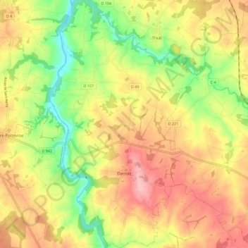
Name: Darnac topographic map, elevation, terrain.
Average elevation: 663 ft
Minimum elevation: 413 ft
Maximum elevation: 886 ft
Other topographic maps
Click on a map to view its topography, its elevation and its terrain.
Darnac
France > New Aquitaine > Val-d'Oire-et-Gartempe > Darnac
Darnac, Val-d'Oire-et-Gartempe, Bellac, Haute-Vienne, New Aquitaine, Metropolitan France, 87320, France
Average elevation: 692 ft