
Shishmaref topographic map
Interactive map
Click on the map to display elevation.
About this map
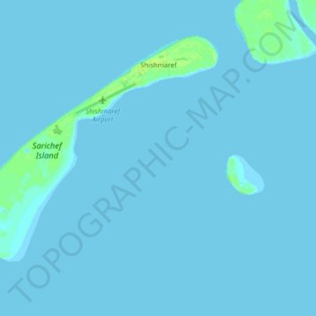
Name: Shishmaref topographic map, elevation, terrain.
Location: Shishmaref, Nome, Alaska, 99772, United States (66.21009 -166.17847 66.26499 -166.01992)
Average elevation: 3 ft
Minimum elevation: -3 ft
Maximum elevation: 33 ft
Other topographic maps
Click on a map to view its topography, its elevation and its terrain.
White Mountain
United States > Alaska > Nome
White Mountain, Nome, Alaska, 99784, United States
Average elevation: 82 ft
Devil Mountain Lakes
United States > Alaska > Nome
Devil Mountain Lakes, Nome, Alaska, United States
Average elevation: 138 ft
Cape York
United States > Alaska > Nome
Cape York, Nome, Alaska, United States
Average elevation: 246 ft
Unalakleet
United States > Alaska > Nome > Unalakleet
Unalakleet, Nome, Alaska, 99684, United States
Average elevation: 85 ft