
Coffee County topographic map
Interactive map
Click on the map to display elevation.
About this map
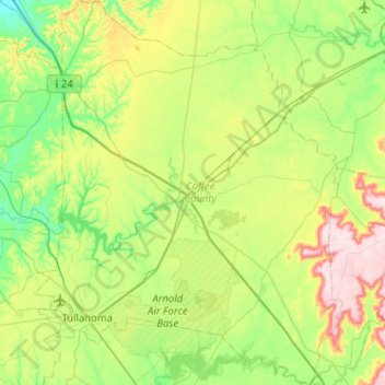
Name: Coffee County topographic map, elevation, terrain.
Location: Coffee County, Middle Tennessee, Tennessee, United States (35.28919 -86.27976 35.70643 -85.86969)
Average elevation: 1,093 ft
Minimum elevation: 682 ft
Maximum elevation: 2,054 ft
Tennessee trails, hiking, mountain biking, running and outdoor activities
Other topographic maps
Click on a map to view its topography, its elevation and its terrain.
Bluegrass Meadows
United States > Tennessee > Sumner County > Hendersonville
Average elevation: 512 ft
Ellington Agricultural Center
United States > Tennessee > Davidson County > Nashville
Average elevation: 584 ft
Belle Rive Highlands
United States > Tennessee > Williamson County > Brentwood
Average elevation: 735 ft
Harpeth River Greenway
United States > Tennessee > Davidson County > Nashville > Harpeth River Estates
Average elevation: 597 ft
Grassland Addition
United States > Tennessee > Cumberland County > Crossville
Average elevation: 1,837 ft
Huntington Ridge Estates
United States > Tennessee > Davidson County > Nashville
Average elevation: 636 ft