
Ironton topographic map
Interactive map
Click on the map to display elevation.
About this map
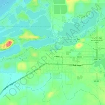
Name: Ironton topographic map, elevation, terrain.
Location: Ironton, Crow Wing County, Minnesota, United States (46.47285 -94.02067 46.48936 -93.97308)
Average elevation: 1,240 ft
Minimum elevation: 1,181 ft
Maximum elevation: 1,378 ft
Other topographic maps
Click on a map to view its topography, its elevation and its terrain.
Bird Island
United States > Minnesota > Crow Wing County
Bird Island, Crow Wing County, Minnesota, United States
Average elevation: 1,266 ft
Brainerd
United States > Minnesota > Crow Wing County
Brainerd, Crow Wing County, Minnesota, 56401, United States
Average elevation: 1,214 ft
Nokay Lake
United States > Minnesota > Crow Wing County
Nokay Lake, Crow Wing County, Minnesota, United States
Average elevation: 1,247 ft
Emily Lake
United States > Minnesota > Crow Wing County > Emily
Emily Lake, Emily, Crow Wing County, Minnesota, United States
Average elevation: 1,266 ft
Cross Lake
United States > Minnesota > Crow Wing County > Crosslake
Cross Lake, Crosslake, Crow Wing County, Minnesota, 56442, United States
Average elevation: 1,237 ft
Breezy Point
United States > Minnesota > Crow Wing County
Breezy Point, Crow Wing County, Minnesota, United States
Average elevation: 1,237 ft
Ossawinnamakee Lake
United States > Minnesota > Crow Wing County > Breezy Point
Ossawinnamakee Lake, Breezy Point, Crow Wing County, Minnesota, United States
Average elevation: 1,247 ft
Boom Lake
United States > Minnesota > Crow Wing County > Brainerd
Boom Lake, Brainerd, Crow Wing County, Minnesota, United States
Average elevation: 1,204 ft
Platte Lake
United States > Minnesota > Crow Wing County
Platte Lake, Crow Wing County, Minnesota, United States
Average elevation: 1,260 ft
Pequot Lakes
United States > Minnesota > Crow Wing County
Pequot Lakes, Crow Wing County, Minnesota, 56472, United States
Average elevation: 1,257 ft
Brainerd
United States > Minnesota > Crow Wing County > Brainerd > Brainerd
Brainerd, Crow Wing County, Minnesota, 56401, United States
Average elevation: 1,211 ft