
Joplin topographic map
Interactive map
Click on the map to display elevation.
About this map
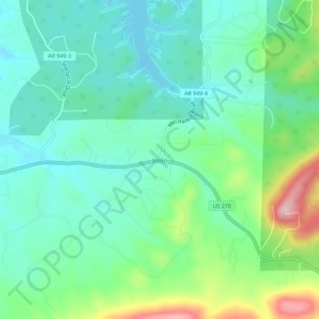
Name: Joplin topographic map, elevation, terrain.
Location: Joplin, Montgomery County, Arkansas, United States (34.52231 -93.47269 34.56231 -93.43269)
Other topographic maps
Click on a map to view its topography, its elevation and its terrain.
Ophir
United States > Arkansas > Montgomery County
Ophir, Montgomery County, Arkansas, United States
Average elevation: 781 ft
Sims
United States > Arkansas > Montgomery County
Sims, Montgomery County, Arkansas, 71969, United States
Average elevation: 745 ft
Mount Ida
United States > Arkansas > Montgomery County
Mount Ida, Montgomery County, Arkansas, United States
Average elevation: 705 ft
Norman
United States > Arkansas > Montgomery County
Norman, Montgomery County, Arkansas, 71960, United States
Average elevation: 745 ft
Mount Ida
United States > Arkansas > Montgomery County > Mount Ida
Mount Ida, Montgomery County, Arkansas, United States
Average elevation: 705 ft
Mount Ida
United States > Arkansas > Montgomery County > Mount Ida > Mount Ida
Mount Ida, Montgomery County, Arkansas, United States
Average elevation: 709 ft