
Basel topographic map
Interactive map
Click on the map to display elevation.
About this map
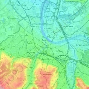
Name: Basel topographic map, elevation, terrain.
Location: Basel, Basel-City, Switzerland (47.51929 7.55466 47.58990 7.63414)
Average elevation: 935 ft
Minimum elevation: 797 ft
Maximum elevation: 1,299 ft
Other topographic maps
Click on a map to view its topography, its elevation and its terrain.
Basel
Switzerland > Basel-City > Basel
Basel, Basel-City, 4001, Switzerland
Average elevation: 1,325 ft