
Grants Pass topographic map
Interactive map
Click on the map to display elevation.
About this map
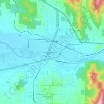
Name: Grants Pass topographic map, elevation, terrain.
Location: Grants Pass, Josephine County, Oregon, United States (42.38969 -123.39400 42.47168 -123.28756)
Average elevation: 1,227 ft
Minimum elevation: 879 ft
Maximum elevation: 3,127 ft
Other topographic maps
Click on a map to view its topography, its elevation and its terrain.
Cave Junction
United States > Oregon > Josephine County
Cave Junction, Josephine County, Oregon, United States
Average elevation: 1,345 ft
Wilderville
United States > Oregon > Josephine County
Wilderville, Josephine County, Oregon, United States
Average elevation: 1,194 ft
O'Brien
United States > Oregon > Josephine County
O'Brien, Josephine County, Oregon, 97534, United States
Average elevation: 1,490 ft
Sunny Valley
United States > Oregon > Josephine County
Sunny Valley, Josephine County, Oregon, 97497, United States
Average elevation: 1,562 ft
Redwood
United States > Oregon > Josephine County
Redwood, Josephine County, Oregon, United States
Average elevation: 984 ft
Fruitdale
United States > Oregon > Josephine County > Grants Pass
Fruitdale, Grants Pass, Josephine County, Oregon, 97506, United States
Average elevation: 1,135 ft
Grants Pass
United States > Oregon > Josephine County
Grants Pass, Josephine County, Oregon, United States
Average elevation: 1,237 ft
Williams
United States > Oregon > Josephine County
Williams, Josephine County, Oregon, 97544, United States
Average elevation: 1,588 ft
Merlin
United States > Oregon > Josephine County
Merlin, Josephine County, Oregon, 57526, United States
Average elevation: 1,010 ft
Galice
United States > Oregon > Josephine County > Galice
Galice, Josephine County, Oregon, United States
Average elevation: 1,319 ft
Wolf Creek
United States > Oregon > Josephine County
Wolf Creek, Josephine County, Oregon, 97497, United States
Average elevation: 1,713 ft