
Breeding topographic map
Interactive map
Click on the map to display elevation.
About this map
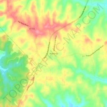
Name: Breeding topographic map, elevation, terrain.
Location: Breeding, Adair County, Kentucky, United States (36.93923 -85.45441 36.97923 -85.41441)
Average elevation: 991 ft
Minimum elevation: 840 ft
Maximum elevation: 1,132 ft
Other topographic maps
Click on a map to view its topography, its elevation and its terrain.
Cane Valley
United States > Kentucky > Adair County
Cane Valley, Adair County, Kentucky, United States
Average elevation: 837 ft
Flatwood
United States > Kentucky > Adair County
Flatwood, Adair County, Kentucky, United States
Average elevation: 827 ft
Barnett Springs
United States > Kentucky > Adair County
Barnett Springs, Adair County, Kentucky, United States
Average elevation: 935 ft
Columbia
United States > Kentucky > Adair County
Columbia, Adair County, Kentucky, 42728, United States
Average elevation: 791 ft
Pickett
United States > Kentucky > Adair County > Pickett
Pickett, Adair County, Kentucky, 42742, United States
Average elevation: 735 ft
Chance
United States > Kentucky > Adair County > Chance
Chance, Adair County, Kentucky, United States
Average elevation: 906 ft