
Berlin topographic map
Interactive map
Click on the map to display elevation.
About this map
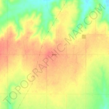
Name: Berlin topographic map, elevation, terrain.
Location: Berlin, Roger Mills County, Oklahoma, United States (35.43061 -99.64538 35.47061 -99.60538)
Average elevation: 2,116 ft
Minimum elevation: 1,998 ft
Maximum elevation: 2,188 ft
Other topographic maps
Click on a map to view its topography, its elevation and its terrain.
Reydon
United States > Oklahoma > Roger Mills County
Reydon, Roger Mills County, Oklahoma, 73660, United States
Average elevation: 2,323 ft
Strong City
United States > Oklahoma > Roger Mills County
Strong City, Roger Mills County, Oklahoma, United States
Average elevation: 1,890 ft
Dempsey
United States > Oklahoma > Roger Mills County
Dempsey, Roger Mills County, Oklahoma, United States
Average elevation: 2,405 ft
Carpenter
United States > Oklahoma > Roger Mills County
Carpenter, Roger Mills County, Oklahoma, United States
Average elevation: 1,959 ft
Hammon
United States > Oklahoma > Roger Mills County
Hammon, Roger Mills County, Oklahoma, 73650, United States
Average elevation: 1,788 ft
Cheyenne
United States > Oklahoma > Roger Mills County
Cheyenne, Roger Mills County, Oklahoma, 73628, United States
Average elevation: 2,001 ft