
Skogafoss topographic map
Interactive map
Click on the map to display elevation.
About this map
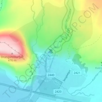
Name: Skogafoss topographic map, elevation, terrain.
Location: Skogafoss, Rangárþing eystra, Southern Region, Iceland (63.53205 -19.51134 63.53215 -19.51124)
Average elevation: 476 ft
Minimum elevation: 56 ft
Maximum elevation: 1,506 ft
Other topographic maps
Click on a map to view its topography, its elevation and its terrain.
Eyjafjallajökull
Eyjafjallajökull, Rangárþing eystra, Southern Region, Iceland
Average elevation: 4,787 ft
Eyjafjallajökull
Eyjafjallajökull, Rangárþing eystra, Southern Region, Iceland
Average elevation: 2,694 ft