
Nineveh topographic map
Interactive map
Click on the map to display elevation.
About this map
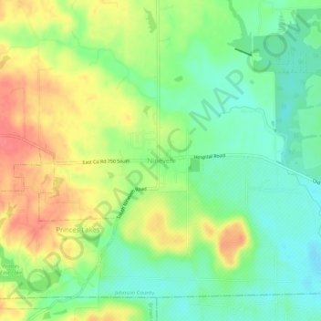
Name: Nineveh topographic map, elevation, terrain.
Location: Nineveh, Johnson County, Indiana, United States (39.34227 -86.10471 39.38227 -86.06471)
Average elevation: 781 ft
Minimum elevation: 689 ft
Maximum elevation: 896 ft
Other topographic maps
Click on a map to view its topography, its elevation and its terrain.
Trafalgar
United States > Indiana > Johnson County
Trafalgar, Johnson County, Indiana, United States
Average elevation: 843 ft
Greenwood
United States > Indiana > Johnson County
Greenwood, Johnson County, Indiana, United States
Average elevation: 804 ft
Bargersville
United States > Indiana > Johnson County
Bargersville, Johnson County, Indiana, 46106, United States
Average elevation: 797 ft
Edinburgh
United States > Indiana > Johnson County
Edinburgh, Johnson County, Indiana, United States
Average elevation: 673 ft
Stones Crossing
United States > Indiana > Johnson County > Greenwood
Stones Crossing, Greenwood, Johnson County, Indiana, 46143, United States
Average elevation: 781 ft
Green Valley
United States > Indiana > Johnson County > Greenwood
Green Valley, Greenwood, Johnson County, Indiana, 46143, United States
Average elevation: 784 ft
Franklin
United States > Indiana > Johnson County
Franklin, Johnson County, Indiana, 46131, United States
Average elevation: 755 ft