
Kerrville topographic map
Interactive map
Click on the map to display elevation.
About this map
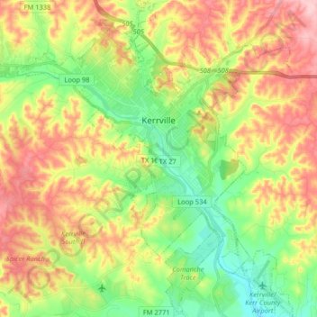
Name: Kerrville topographic map, elevation, terrain.
Location: Kerrville, Kerr County, Texas, United States (29.96182 -99.21161 30.10132 -99.07165)
Average elevation: 1,788 ft
Minimum elevation: 1,522 ft
Maximum elevation: 2,119 ft
Other topographic maps
Click on a map to view its topography, its elevation and its terrain.
Center Point
United States > Texas > Kerr County
Center Point, Kerr County, Texas, United States
Average elevation: 1,545 ft
Kerrville-Schreiner Park
United States > Texas > Kerr County > Kerrville
Kerrville-Schreiner Park, 2385, Kerrville, Kerr County, Texas, 78028, United States
Average elevation: 1,627 ft
Camp Verde
United States > Texas > Kerr County
Camp Verde, Kerr County, Texas, 78010, United States
Average elevation: 1,726 ft
Kerrville
United States > Texas > Kerr County
Kerrville, Kerr County, Texas, United States
Average elevation: 1,788 ft
Guadalupe River
United States > Texas > Kerr County > Kerrville
Guadalupe River, Kerrville, Kerr County, Texas, 78029, United States
Average elevation: 1,673 ft
Hunt
United States > Texas > Kerr County
Hunt, Kerr County, Texas, 78024, United States
Average elevation: 1,877 ft
Kerrville
United States > Texas > Kerr County > Kerrville
Kerrville, Kerr County, Texas, 78029, United States
Average elevation: 1,752 ft
Cypress Creek
United States > Texas > Kerr County
Cypress Creek, Kerr County, Texas, United States
Average elevation: 1,614 ft
Mountain Home
United States > Texas > Kerr County
Mountain Home, Kerr County, Texas, 78058, United States
Average elevation: 2,011 ft
Ingram
United States > Texas > Kerr County
Ingram, Kerr County, Texas, United States
Average elevation: 1,781 ft