
Wells topographic map
Interactive map
Click on the map to display elevation.
About this map
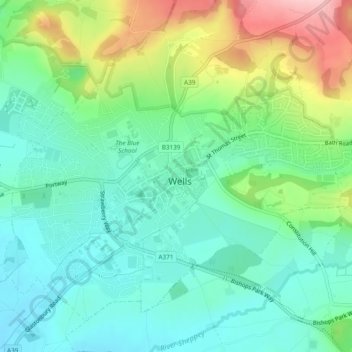
Name: Wells topographic map, elevation, terrain.
Location: Wells, Somerset, England, United Kingdom (51.19764 -2.66890 51.22207 -2.62136)
Average elevation: 226 ft
Minimum elevation: 52 ft
Maximum elevation: 610 ft
Other topographic maps
Click on a map to view its topography, its elevation and its terrain.
West Bradley
United Kingdom > England > Somerset
West Bradley, Somerset, England, United Kingdom
Average elevation: 164 ft
Woolavington
United Kingdom > England > Somerset
Woolavington, Somerset, England, United Kingdom
Average elevation: 56 ft
Low Ham
United Kingdom > England > Somerset > High Ham
Low Ham, High Ham, Somerset, England, TA10 9DZ, United Kingdom
Average elevation: 148 ft
Langport
United Kingdom > England > Somerset
Langport, Somerset, England, United Kingdom
Average elevation: 59 ft
Castle Cary
United Kingdom > England > Somerset
Castle Cary, Somerset, England, United Kingdom
Average elevation: 223 ft
North Barrow
United Kingdom > England > Somerset
North Barrow, Somerset, England, United Kingdom
Average elevation: 121 ft
Shurton
United Kingdom > England > Somerset > Stogursey
Shurton, Stogursey, Somerset, England, TA5 1QE, United Kingdom
Average elevation: 85 ft
Sutton
United Kingdom > England > Somerset > Alhampton
Sutton, Ditcheat, Alhampton, Somerset, England, BA4 6QQ, United Kingdom
Average elevation: 154 ft
Frome
United Kingdom > England > Somerset
Frome, Somerset, England, United Kingdom
Average elevation: 295 ft
Yeovil
United Kingdom > England > Somerset > South Somerset
Yeovil, South Somerset, Somerset, England, United Kingdom
Average elevation: 207 ft
Wedmore
United Kingdom > England > Somerset
Wedmore, Somerset, England, United Kingdom
Average elevation: 49 ft
Street
United Kingdom > England > Somerset > Mendip
Street, Mendip, Somerset, England, United Kingdom
Average elevation: 75 ft
Aller
United Kingdom > England > Somerset > South Somerset
Aller, South Somerset, Somerset, England, TA10 0QZ, United Kingdom
Average elevation: 92 ft
Axbridge
United Kingdom > England > Somerset > Sedgemoor
Axbridge, Sedgemoor, Somerset, England, United Kingdom
Average elevation: 220 ft
Exmoor National Park
United Kingdom > England > Somerset
Exmoor National Park, Somerset, England, United Kingdom
Average elevation: 476 ft
Luxborough
United Kingdom > England > Somerset > Somerset West and Taunton
Luxborough, Somerset West and Taunton, Somerset, England, United Kingdom
Average elevation: 958 ft
Minehead
United Kingdom > England > Somerset > Somerset West and Taunton
Minehead, Somerset West and Taunton, Somerset, England, United Kingdom
Average elevation: 282 ft
Highbridge
United Kingdom > England > Somerset > Sedgemoor > Highbridge
Highbridge, Sedgemoor, Somerset, England, TA9 3HG, United Kingdom
Average elevation: 20 ft
Wembdon
United Kingdom > England > Somerset > Sedgemoor
Wembdon, Sedgemoor, Somerset, England, United Kingdom
Average elevation: 30 ft
Broad River
United Kingdom > England > Somerset > South Somerset > West Chinnock
Broad River, West Chinnock, South Somerset, Somerset, England, TA18 7PL, United Kingdom
Average elevation: 200 ft
Allerford
United Kingdom > England > Somerset > Somerset West and Taunton > Allerford
Allerford, Somerset West and Taunton, Somerset, England, TA24 8HN, United Kingdom
Average elevation: 367 ft
Cannington
United Kingdom > England > Somerset > Sedgemoor
Cannington, Sedgemoor, Somerset, England, United Kingdom
Average elevation: 95 ft
Porlock
United Kingdom > England > Somerset > Somerset West and Taunton > Porlock
Porlock, Somerset West and Taunton, Somerset, England, United Kingdom
Average elevation: 679 ft
Bossington
United Kingdom > England > Somerset > Somerset West and Taunton > Bossington
Bossington, Somerset West and Taunton, Somerset, England, TA24 8HQ, United Kingdom
Average elevation: 226 ft
Horner Water
United Kingdom > England > Somerset > Somerset West and Taunton > Luccombe
Horner Water, Luccombe, Somerset West and Taunton, Somerset, England, TA24 8HY, United Kingdom
Average elevation: 814 ft
Halse Combe
United Kingdom > England > Somerset > Somerset West and Taunton > Allerford > Horner
Halse Combe, Horner, Luccombe, Allerford, Somerset West and Taunton, Somerset, England, TA24 8HX, United Kingdom
Average elevation: 440 ft
Glastonbury
United Kingdom > England > Somerset > Mendip District
Glastonbury, Mendip District, Somerset, England, United Kingdom
Average elevation: 49 ft
Watchet
United Kingdom > England > Somerset > Somerset West and Taunton
Watchet, Somerset West and Taunton, Somerset, England, United Kingdom
Average elevation: 66 ft
Shepton Mallet
United Kingdom > England > Somerset > Mendip District > Shepton Mallet
Shepton Mallet, Mendip District, Somerset, South West England, England, United Kingdom
Average elevation: 568 ft
Cheddar
United Kingdom > England > Somerset > Sedgemoor
Cheddar, Sedgemoor, Somerset, England, United Kingdom
Average elevation: 358 ft
Norton St Philip
United Kingdom > England > Somerset > Mendip
Norton St Philip, Mendip, Somerset, South West England, England, United Kingdom
Average elevation: 295 ft
Holcombe
United Kingdom > England > Somerset > Mendip
Holcombe, Mendip, Somerset, South West England, England, United Kingdom
Average elevation: 545 ft
Drayton
United Kingdom > England > Somerset
Drayton, Somerset, England, United Kingdom
Average elevation: 59 ft
Bridgwater
United Kingdom > England > Somerset
Bridgwater, Somerset, England, United Kingdom
Average elevation: 33 ft
Taunton
United Kingdom > England > Somerset > Somerset West and Taunton
Taunton, Somerset West and Taunton, Somerset, England, TA1 1JD, United Kingdom
Average elevation: 128 ft