
Ponemah topographic map
Interactive map
Click on the map to display elevation.
About this map
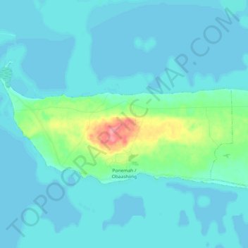
Name: Ponemah topographic map, elevation, terrain.
Location: Ponemah, Beltrami County, Minnesota, 56666, United States (48.01355 -95.00636 48.07644 -94.82388)
Average elevation: 1,188 ft
Minimum elevation: 1,158 ft
Maximum elevation: 1,404 ft
Other topographic maps
Click on a map to view its topography, its elevation and its terrain.
Green Lake
United States > Minnesota > Beltrami County > Little Rock
Green Lake, Little Rock, Beltrami County, Minnesota, United States
Average elevation: 1,243 ft
Bemidji
United States > Minnesota > Beltrami County
Bemidji, Beltrami County, Minnesota, 56601, United States
Average elevation: 1,368 ft
Movil Lake Dam
United States > Minnesota > Beltrami County
Movil Lake Dam, Beltrami County, Minnesota, United States
Average elevation: 1,365 ft
Waskish
United States > Minnesota > Beltrami County
Waskish, Beltrami County, Minnesota, 56685, United States
Average elevation: 1,178 ft
Little Rock
United States > Minnesota > Beltrami County
Little Rock, Beltrami County, Minnesota, United States
Average elevation: 1,230 ft
Long Lake
United States > Minnesota > Beltrami County
Long Lake, Beltrami County, Minnesota, United States
Average elevation: 1,378 ft
Solway
United States > Minnesota > Beltrami County > Solway
Solway, Beltrami County, Minnesota, United States
Average elevation: 1,444 ft
Bemidji
United States > Minnesota > Beltrami County > Bemidji
Bemidji, Beltrami County, Minnesota, 56601, United States
Average elevation: 1,365 ft
Lake Bemidji
United States > Minnesota > Beltrami County > Bemidji
Lake Bemidji, Bemidji, Beltrami County, Minnesota, 56601, United States
Average elevation: 1,362 ft
Wilton
United States > Minnesota > Beltrami County
Wilton, Beltrami County, Minnesota, 56687, United States
Average elevation: 1,394 ft