
Three Point topographic map
Interactive map
Click on the map to display elevation.
About this map
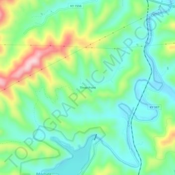
Name: Three Point topographic map, elevation, terrain.
Location: Three Point, Harlan County, Kentucky, 40815, United States (36.74342 -83.28018 36.78342 -83.24018)
Average elevation: 1,558 ft
Minimum elevation: 1,257 ft
Maximum elevation: 2,251 ft
Other topographic maps
Click on a map to view its topography, its elevation and its terrain.
Pathfork
United States > Kentucky > Harlan County
Pathfork, Harlan County, Kentucky, 40863, United States
Average elevation: 1,752 ft
Lenarue
United States > Kentucky > Harlan County
Lenarue, Harlan County, Kentucky, 40818, United States
Average elevation: 1,703 ft
Bardo
United States > Kentucky > Harlan County
Bardo, Harlan County, Kentucky, 40830, United States
Average elevation: 2,080 ft
Holmes Mill
United States > Kentucky > Harlan County
Holmes Mill, Harlan County, Kentucky, 40843, United States
Average elevation: 2,487 ft
Pansy
United States > Kentucky > Harlan County
Pansy, Harlan County, Kentucky, 40830, United States
Average elevation: 1,975 ft
Putney
United States > Kentucky > Harlan County
Putney, Harlan County, Kentucky, 40865, United States
Average elevation: 1,972 ft
Alva
United States > Kentucky > Harlan County
Alva, Harlan County, Kentucky, 40863, United States
Average elevation: 2,139 ft
Yancey
United States > Kentucky > Harlan County
Yancey, Harlan County, Kentucky, 40830, United States
Average elevation: 2,136 ft
Fresh Meadows
United States > Kentucky > Harlan County
Fresh Meadows, Harlan County, Kentucky, 40824, United States
Average elevation: 1,516 ft
Pine Mountain
United States > Kentucky > Harlan County
Pine Mountain, Harlan County, Kentucky, United States
Average elevation: 1,759 ft
Kenvir
United States > Kentucky > Harlan County
Kenvir, Harlan County, Kentucky, 40847, United States
Average elevation: 2,106 ft
Ages
United States > Kentucky > Harlan County
Ages, Harlan County, Kentucky, 40801, United States
Average elevation: 1,926 ft
Wallins Creek
United States > Kentucky > Harlan County
Wallins Creek, Harlan County, Kentucky, United States
Average elevation: 1,365 ft
Lejunior
United States > Kentucky > Harlan County
Lejunior, Harlan County, Kentucky, 40865, United States
Average elevation: 1,919 ft
Louellen
United States > Kentucky > Harlan County
Louellen, Harlan County, Kentucky, 40849, United States
Average elevation: 2,290 ft
Big Laurel
United States > Kentucky > Harlan County
Big Laurel, Harlan County, Kentucky, 40808, United States
Average elevation: 1,883 ft
Cawood
United States > Kentucky > Harlan County
Cawood, Harlan County, Kentucky, 40818, United States
Average elevation: 1,634 ft
South Wallins
United States > Kentucky > Harlan County > South Wallins
South Wallins, Harlan County, Kentucky, 40873, United States
Average elevation: 1,732 ft
Dayhoit
United States > Kentucky > Harlan County
Dayhoit, Harlan County, Kentucky, 40824, United States
Average elevation: 1,516 ft
Loyall
United States > Kentucky > Harlan County
Loyall, Harlan County, Kentucky, 40854, United States
Average elevation: 1,424 ft
Molus
United States > Kentucky > Harlan County
Molus, Harlan County, Kentucky, 40819, United States
Average elevation: 1,532 ft
Closplint
United States > Kentucky > Harlan County
Closplint, Harlan County, Kentucky, 40927, United States
Average elevation: 2,349 ft
Benham
United States > Kentucky > Harlan County
Benham, Harlan County, Kentucky, 40807, United States
Average elevation: 2,188 ft
Totz
United States > Kentucky > Harlan County
Totz, Harlan County, Kentucky, 40870, United States
Average elevation: 2,093 ft
Bledsoe
United States > Kentucky > Harlan County
Bledsoe, Harlan County, Kentucky, 40810, United States
Average elevation: 1,982 ft
Creech
United States > Kentucky > Harlan County
Creech, Harlan County, Kentucky, United States
Average elevation: 2,169 ft
River Ridge
United States > Kentucky > Harlan County
River Ridge, Harlan County, Kentucky, 40828, United States
Average elevation: 1,916 ft
Evarts
United States > Kentucky > Harlan County
Evarts, Harlan County, Kentucky, United States
Average elevation: 1,749 ft
Baxter
United States > Kentucky > Harlan County
Baxter, Harlan County, Kentucky, 40806, United States
Average elevation: 1,535 ft
Coldiron
United States > Kentucky > Harlan County
Coldiron, Harlan County, Kentucky, 40819, United States
Average elevation: 1,549 ft
Lynch
United States > Kentucky > Harlan County
Lynch, Harlan County, Kentucky, United States
Average elevation: 2,526 ft
Divide
United States > Kentucky > Harlan County
Divide, Harlan County, Kentucky, 40865, United States
Average elevation: 2,156 ft
Cranks
United States > Kentucky > Harlan County
Cranks, Harlan County, Kentucky, 40820, United States
Average elevation: 1,949 ft
Harlan
United States > Kentucky > Harlan County
Harlan, Harlan County, Kentucky, 40831, United States
Average elevation: 1,617 ft
Harlan
United States > Kentucky > Harlan County > Harlan > Harlan
Harlan, Harlan County, Kentucky, 40831, United States
Average elevation: 1,680 ft
Cumberland
United States > Kentucky > Harlan County
Cumberland, Harlan County, Kentucky, 40823, United States
Average elevation: 1,939 ft