
Jacksonville topographic map
Interactive map
Click on the map to display elevation.
About this map
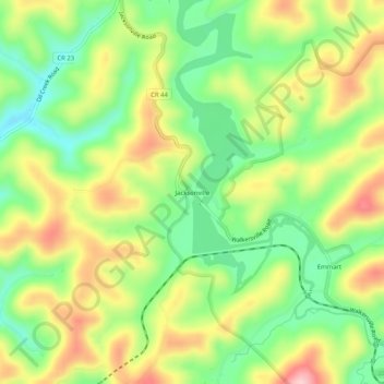
Name: Jacksonville topographic map, elevation, terrain.
Location: Jacksonville, Lewis County, West Virginia, United States (38.87093 -80.51203 38.91093 -80.47203)
Average elevation: 1,194 ft
Minimum elevation: 906 ft
Maximum elevation: 1,562 ft
Other topographic maps
Click on a map to view its topography, its elevation and its terrain.
Weston
United States > West Virginia > Lewis County
Weston, Lewis County, West Virginia, 26452, United States
Average elevation: 1,178 ft
Roanoke
United States > West Virginia > Lewis County
Roanoke, Lewis County, West Virginia, 26447, United States
Average elevation: 1,201 ft