
Utica topographic map
Interactive map
Click on the map to display elevation.
About this map
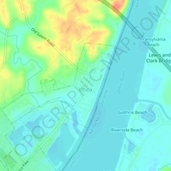
Name: Utica topographic map, elevation, terrain.
Location: Utica, Clark County, Indiana, United States (38.32752 -85.67050 38.34105 -85.64719)
Average elevation: 466 ft
Minimum elevation: 423 ft
Maximum elevation: 581 ft
Other topographic maps
Click on a map to view its topography, its elevation and its terrain.
Starlight
United States > Indiana > Clark County
Starlight, Clark County, Indiana, 47106, United States
Average elevation: 837 ft
Underwood
United States > Indiana > Clark County
Underwood, Clark County, Indiana, 47177, United States
Average elevation: 636 ft
Rolling Hills
United States > Indiana > Clark County
Rolling Hills, Clark County, Indiana, United States
Average elevation: 643 ft
Henryville
United States > Indiana > Clark County
Henryville, Clark County, Indiana, 47126, United States
Average elevation: 545 ft
Marysville
United States > Indiana > Clark County
Marysville, Clark County, Indiana, United States
Average elevation: 692 ft
Otisco
United States > Indiana > Clark County
Otisco, Clark County, Indiana, 47163, United States
Average elevation: 650 ft
Nabb
United States > Indiana > Clark County
Nabb, Clark County, Indiana, United States
Average elevation: 696 ft
Bethlehem
United States > Indiana > Clark County
Bethlehem, Clark County, Indiana, 47104, United States
Average elevation: 558 ft
New Washington
United States > Indiana > Clark County
New Washington, Clark County, Indiana, United States
Average elevation: 702 ft
Oak Park
United States > Indiana > Clark County
Oak Park, Clark County, Indiana, United States
Average elevation: 459 ft
Borden
United States > Indiana > Clark County
Borden, Clark County, Indiana, United States
Average elevation: 722 ft
Sellersburg
United States > Indiana > Clark County
Sellersburg, Clark County, Indiana, 47172, United States
Average elevation: 489 ft
Memphis
United States > Indiana > Clark County
Memphis, Clark County, Indiana, United States
Average elevation: 502 ft
Port Fulton
United States > Indiana > Clark County > Jeffersonville
Port Fulton, Jeffersonville, Clark County, Indiana, 47130, United States
Average elevation: 459 ft
Jeffersonville
United States > Indiana > Clark County
Jeffersonville, Clark County, Indiana, United States
Average elevation: 492 ft
Charlestown
United States > Indiana > Clark County
Charlestown, Clark County, Indiana, 47111, United States
Average elevation: 558 ft
Owen
United States > Indiana > Clark County
Owen, Clark County, Indiana, United States
Average elevation: 597 ft
Speed
United States > Indiana > Clark County > Speed
Speed, Clark County, Indiana, 47172, United States
Average elevation: 482 ft
Clarksville
United States > Indiana > Clark County
Clarksville, Clark County, Indiana, United States
Average elevation: 492 ft