
Gravity topographic map
Interactive map
Click on the map to display elevation.
About this map
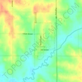
Name: Gravity topographic map, elevation, terrain.
Location: Gravity, Taylor County, Iowa, United States (40.75445 -94.74774 40.76647 -94.73894)
Average elevation: 1,204 ft
Minimum elevation: 1,138 ft
Maximum elevation: 1,283 ft
Other topographic maps
Click on a map to view its topography, its elevation and its terrain.
Lenox
United States > Iowa > Taylor County > Lenox
Lenox, Taylor County, Iowa, 50851, United States
Average elevation: 1,276 ft
Lenox
United States > Iowa > Taylor County
Lenox, Taylor County, Iowa, 50851, United States
Average elevation: 1,280 ft
Sharpsburg
United States > Iowa > Taylor County
Sharpsburg, Taylor County, Iowa, United States
Average elevation: 1,270 ft