
Blanford topographic map
Interactive map
Click on the map to display elevation.
About this map
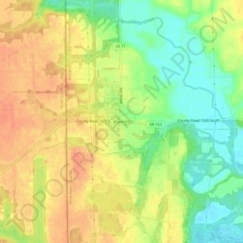
Name: Blanford topographic map, elevation, terrain.
Location: Blanford, Vermillion County, Indiana, 47831, United States (39.64504 -87.54058 39.68504 -87.50058)
Average elevation: 574 ft
Minimum elevation: 489 ft
Maximum elevation: 643 ft
Other topographic maps
Click on a map to view its topography, its elevation and its terrain.
Fairview Park
United States > Indiana > Vermillion County
Fairview Park, Vermillion County, Indiana, United States
Average elevation: 535 ft
Tighe
United States > Indiana > Vermillion County
Tighe, Vermillion County, Indiana, 47831, United States
Average elevation: 597 ft
Hillsdale
United States > Indiana > Vermillion County > Highland > Hillsdale
Hillsdale, Highland, Vermillion County, Indiana, 47862, United States
Average elevation: 545 ft