
Glacier National Park topographic map
Interactive map
Click on the map to display elevation.
About this map
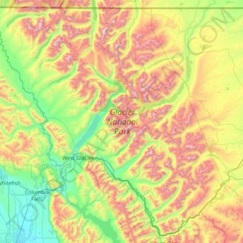
Name: Glacier National Park topographic map, elevation, terrain.
Average elevation: 5,230 ft
Minimum elevation: 2,913 ft
Maximum elevation: 10,010 ft
One of the most dramatic evidences of this overthrust is visible in the form of Chief Mountain, an isolated peak on the edge of the eastern boundary of the park rising 2,500 feet (800 m) above the Great Plains. There are six mountains in the park over 10,000 feet (3,000 m) in elevation, with Mount Cleveland at 10,466 feet (3,190 m) being the tallest. Appropriately named Triple Divide Peak sends waters towards the Pacific Ocean, Hudson Bay, and Gulf of Mexico watersheds. This peak can effectively be considered to be the apex of the North American continent, although the mountain is only 8,020 feet (2,444 m) above sea level.
Other topographic maps
Click on a map to view its topography, its elevation and its terrain.
Whitefish
United States > Montana > Flathead County
Whitefish, Flathead County, Montana, United States
Average elevation: 3,520 ft
Logan Pass
United States > Montana > Flathead County
Logan Pass, Flathead County, Montana, United States
Average elevation: 6,693 ft
Kalispell
United States > Montana > Flathead County
Kalispell, Flathead County, Montana, United States
Average elevation: 3,064 ft
Marion
United States > Montana > Flathead County
Marion, Flathead County, Montana, United States
Average elevation: 4,055 ft
Niarada
United States > Montana > Flathead County
Niarada, Flathead County, Montana, United States
Average elevation: 3,455 ft
Evergreen
United States > Montana > Flathead County
Evergreen, Flathead County, Montana, United States
Average elevation: 2,936 ft
Columbia Falls
United States > Montana > Flathead County
Columbia Falls, Flathead County, Montana, 59912, United States
Average elevation: 3,064 ft
Condor Peak
United States > Montana > Flathead County
Condor Peak, Flathead County, Montana, United States
Average elevation: 6,063 ft
Apgar
United States > Montana > Flathead County
Apgar, Flathead County, Montana, 59936, United States
Average elevation: 3,543 ft
Somers
United States > Montana > Flathead County
Somers, Flathead County, Montana, United States
Average elevation: 3,002 ft
Lakeside
United States > Montana > Flathead County
Lakeside, Flathead County, Montana, 59922, United States
Average elevation: 3,392 ft
Bigfork
United States > Montana > Flathead County
Bigfork, Flathead County, Montana, United States
Average elevation: 3,025 ft
Bowman Lake
United States > Montana > Flathead County
Bowman Lake, Flathead County, Montana, United States
Average elevation: 5,377 ft
Kalispell
United States > Montana > Flathead County > Kalispell
Kalispell, Flathead County, Montana, 59901-4451, United States
Average elevation: 3,461 ft
Polebridge
United States > Montana > Flathead County
Polebridge, Flathead County, Montana, 59928, United States
Average elevation: 3,668 ft
Canyon Point
United States > Montana > Flathead County
Canyon Point, Flathead County, Montana, United States
Average elevation: 5,741 ft
Graves Creek
United States > Montana > Flathead County
Graves Creek, Flathead County, Montana, United States
Average elevation: 5,558 ft
Lake McDonald
United States > Montana > Flathead County
Lake McDonald, Flathead County, Montana, United States
Average elevation: 3,967 ft
Kila
United States > Montana > Flathead County
Kila, Flathead County, Montana, 59920, United States
Average elevation: 3,323 ft
Lake Ellen Wilson
United States > Montana > Flathead County
Lake Ellen Wilson, Flathead County, Montana, United States
Average elevation: 6,890 ft
West Glacier
United States > Montana > Flathead County
West Glacier, Flathead County, Montana, 59936, United States
Average elevation: 3,940 ft
Coal Creek
United States > Montana > Flathead County
Coal Creek, Flathead County, Montana, United States
Average elevation: 4,222 ft
Cone Peak
United States > Montana > Flathead County
Cone Peak, Flathead County, Montana, United States
Average elevation: 5,968 ft
Heavens Peak
United States > Montana > Flathead County
Heavens Peak, Flathead County, Montana, United States
Average elevation: 6,742 ft