
Shavertown topographic map
Interactive map
Click on the map to display elevation.
About this map
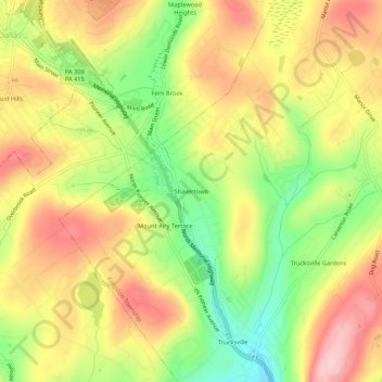
Name: Shavertown topographic map, elevation, terrain.
Average elevation: 1,158 ft
Minimum elevation: 830 ft
Maximum elevation: 1,447 ft
Other topographic maps
Click on a map to view its topography, its elevation and its terrain.
Trucksville
United States > Pennsylvania > Luzerne County > Kingston Township
Trucksville, Kingston Township, Luzerne County, Pennsylvania, 18708, United States
Average elevation: 1,125 ft