
Dolman Island topographic map
Interactive map
Click on the map to display elevation.
About this map
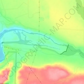
Name: Dolman Island topographic map, elevation, terrain.
Location: Dolman Island, Twin Falls County, Idaho, United States (42.76403 -114.91575 42.77172 -114.89603)
Average elevation: 2,943 ft
Minimum elevation: 2,785 ft
Maximum elevation: 3,107 ft
Other topographic maps
Click on a map to view its topography, its elevation and its terrain.
Twin Falls
United States > Idaho > Twin Falls County
Twin Falls, Twin Falls County, Idaho, 83301, United States
Average elevation: 3,734 ft
Hansen
United States > Idaho > Twin Falls County
Hansen, Twin Falls County, Idaho, United States
Average elevation: 4,026 ft
Buhl
United States > Idaho > Twin Falls County
Buhl, Twin Falls County, Idaho, United States
Average elevation: 3,770 ft
Filer
United States > Idaho > Twin Falls County
Filer, Twin Falls County, Idaho, United States
Average elevation: 3,770 ft
Kimberly
United States > Idaho > Twin Falls County
Kimberly, Twin Falls County, Idaho, 83441, United States
Average elevation: 3,921 ft