
Pike Road topographic map
Interactive map
Click on the map to display elevation.
About this map
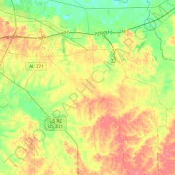
Name: Pike Road topographic map, elevation, terrain.
Location: Pike Road, Montgomery County, Alabama, 36064, United States (32.20707 -86.21740 32.39095 -85.95852)
Average elevation: 240 ft
Minimum elevation: 148 ft
Maximum elevation: 344 ft
Other topographic maps
Click on a map to view its topography, its elevation and its terrain.
Cloverland
United States > Alabama > Montgomery County > Montgomery
Cloverland, Montgomery, Montgomery County, Alabama, 36104, United States
Average elevation: 220 ft
Johnstown East
United States > Alabama > Montgomery County > Montgomery
Johnstown East, Montgomery, Montgomery County, Alabama, 36109, United States
Average elevation: 240 ft
Montgomery
United States > Alabama > Montgomery County
Montgomery, Montgomery County, Alabama, United States
Average elevation: 210 ft
Flatwood
United States > Alabama > Montgomery County
Flatwood, Montgomery County, Alabama, 36110, United States
Average elevation: 161 ft
Cooks
United States > Alabama > Montgomery County
Cooks, Montgomery County, Alabama, 36124, United States
Average elevation: 167 ft
Landmarks
United States > Alabama > Montgomery County > Montgomery > Landmarks
Landmarks, Montgomery, Montgomery County, Alabama, 36119, United States
Average elevation: 236 ft
Lapine
United States > Alabama > Montgomery County
Lapine, Montgomery County, Alabama, United States
Average elevation: 456 ft