
Bowling Green topographic map
Interactive map
Click on the map to display elevation.
About this map
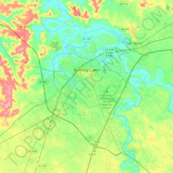
Name: Bowling Green topographic map, elevation, terrain.
Location: Bowling Green, Warren County, Kentucky, 42101, United States (36.89885 -86.53321 37.04665 -86.30672)
Average elevation: 554 ft
Minimum elevation: 417 ft
Maximum elevation: 814 ft
Other topographic maps
Click on a map to view its topography, its elevation and its terrain.
Rockfield
United States > Kentucky > Warren County
Rockfield, Warren County, Kentucky, 42274, United States
Average elevation: 587 ft
Plano
United States > Kentucky > Warren County
Plano, Warren County, Kentucky, 42102, United States
Average elevation: 597 ft
Richardsville
United States > Kentucky > Warren County
Richardsville, Warren County, Kentucky, United States
Average elevation: 597 ft
Alvaton
United States > Kentucky > Warren County
Alvaton, Warren County, Kentucky, 42122, United States
Average elevation: 597 ft
Smiths Grove
United States > Kentucky > Warren County
Smiths Grove, Warren County, Kentucky, United States
Average elevation: 633 ft
Springhill
United States > Kentucky > Warren County > Bowling Green > Springhill
Springhill, Bowling Green, Warren County, Kentucky, 42101-1000, United States
Average elevation: 509 ft