
Princeton topographic map
Interactive map
Click on the map to display elevation.
About this map
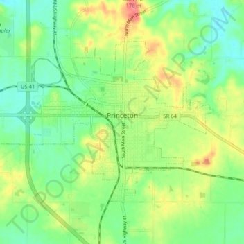
Name: Princeton topographic map, elevation, terrain.
Location: Princeton, Gibson County, Indiana, 47670, United States (38.33329 -87.61717 38.37423 -87.53832)
Average elevation: 489 ft
Minimum elevation: 404 ft
Maximum elevation: 623 ft
Other topographic maps
Click on a map to view its topography, its elevation and its terrain.
Mounts
United States > Indiana > Gibson County
Mounts, Gibson County, Indiana, 47612, United States
Average elevation: 463 ft
East Mount Carmel
United States > Indiana > Gibson County > White River
East Mount Carmel, White River, Gibson County, Indiana, United States
Average elevation: 400 ft
Patoka River
United States > Indiana > Gibson County
Patoka River, Gibson County, Indiana, United States
Average elevation: 423 ft
Fort Branch
United States > Indiana > Gibson County > Fort Branch
Fort Branch, Gibson County, Indiana, 47648, United States
Average elevation: 446 ft
Owensville
United States > Indiana > Gibson County
Owensville, Gibson County, Indiana, 47665, United States
Average elevation: 499 ft