
Daleville topographic map
Interactive map
Click on the map to display elevation.
About this map
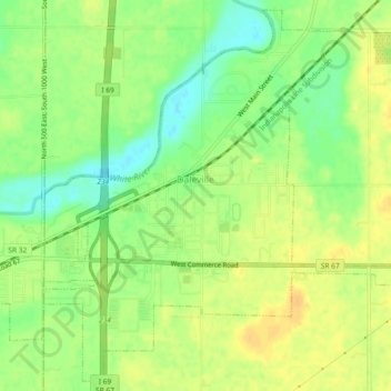
Name: Daleville topographic map, elevation, terrain.
Location: Daleville, Delaware County, Indiana, United States (40.10292 -85.57606 40.13647 -85.52995)
Average elevation: 919 ft
Minimum elevation: 863 ft
Maximum elevation: 958 ft
Other topographic maps
Click on a map to view its topography, its elevation and its terrain.
Albany
United States > Indiana > Delaware County
Albany, Delaware County, Indiana, 47320, United States
Average elevation: 951 ft
Oakville
United States > Indiana > Delaware County
Oakville, Delaware County, Indiana, 47367, United States
Average elevation: 1,014 ft
Royerton
United States > Indiana > Delaware County
Royerton, Delaware County, Indiana, 47303, United States
Average elevation: 935 ft
Gaston
United States > Indiana > Delaware County
Gaston, Delaware County, Indiana, United States
Average elevation: 896 ft
Eaton
United States > Indiana > Delaware County
Eaton, Delaware County, Indiana, 47338, United States
Average elevation: 915 ft
Cowan
United States > Indiana > Delaware County
Cowan, Delaware County, Indiana, 47367, United States
Average elevation: 994 ft
Yorktown
United States > Indiana > Delaware County
Yorktown, Delaware County, Indiana, United States
Average elevation: 925 ft
White River
United States > Indiana > Delaware County > Yorktown
White River, Yorktown, Delaware County, Indiana, United States
Average elevation: 925 ft
Prairie Creek Reservoir
United States > Indiana > Delaware County
Prairie Creek Reservoir, Delaware County, Indiana, United States
Average elevation: 1,014 ft
Muncie
United States > Indiana > Delaware County
Muncie, Delaware County, Indiana, United States
Average elevation: 955 ft
Selma
United States > Indiana > Delaware County
Selma, Delaware County, Indiana, United States
Average elevation: 997 ft
Muncie
United States > Indiana > Delaware County > Muncie
Muncie, Delaware County, Indiana, 47305, United States
Average elevation: 965 ft
Creston
United States > Indiana > Delaware County > Muncie > Creston
Creston, Muncie, Delaware County, Indiana, 47303, United States
Average elevation: 958 ft