L'Escale topographic map
Interactive map
Click on the map to display elevation.
About this map
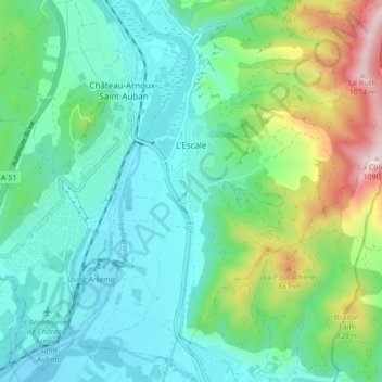
Name: L'Escale topographic map, elevation, terrain.
Average elevation: 1,850 ft
Minimum elevation: 1,312 ft
Maximum elevation: 3,524 ft

Click on the map to display elevation.
Name: L'Escale topographic map, elevation, terrain.
Average elevation: 1,850 ft
Minimum elevation: 1,312 ft
Maximum elevation: 3,524 ft