
Crookston topographic map
Interactive map
Click on the map to display elevation.
About this map
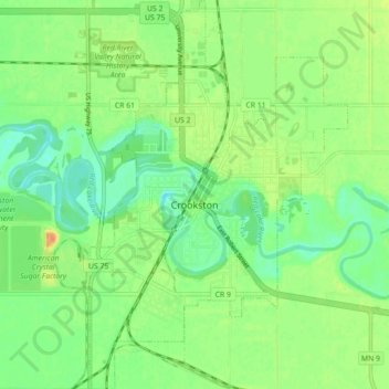
Name: Crookston topographic map, elevation, terrain.
Location: Crookston, Polk County, Minnesota, 56716, United States (47.74570 -96.63214 47.80520 -96.57326)
Average elevation: 883 ft
Minimum elevation: 830 ft
Maximum elevation: 951 ft
Other topographic maps
Click on a map to view its topography, its elevation and its terrain.
East Grand Forks
United States > Minnesota > Polk County
East Grand Forks, Polk County, Minnesota, 56721, United States
Average elevation: 837 ft
Lengby
United States > Minnesota > Polk County
Lengby, Polk County, Minnesota, United States
Average elevation: 1,388 ft
Fosston
United States > Minnesota > Polk County
Fosston, Polk County, Minnesota, 56542, United States
Average elevation: 1,289 ft
Nielsville
United States > Minnesota > Polk County
Nielsville, Polk County, Minnesota, United States
Average elevation: 869 ft